Tag Archives: Atmospheric River

Drought Conditions Improving after Atmospheric Rivers Drench California

A look at the progress so far as another storm looms

California has been some form of drought condition for most of the time since 2008. By September 2022 there were severe drought conditions in nearly all of the state. This was exacerbated by the driest first three months of any year at the beginning of 2022. Although December 2021 had precipitation and the snow pack was improved somewhat, it was not enough and this led to the extreme drought conditions by fall 2022.

Atmospheric Rivers are a dangerous threat, but also bring large amounts of moisture

Another storm front of this type is expected for the weekend, and, while most of us have had more than enough of the floods and generally wet nasty conditions, the chances for improving the historic drought extremes have increased and we can continue to benefit.

The atmospheric rivers that we’ve seen in near continuous succession have brought a significant amount of rain, snow and moisture, making this one of the wettest winters in the record books.

It has, unfortunately, also been a destructive and deadly series of storms and there is still a danger that that aspect of the phenomenon will continue as well.

The US Drought Monitor has data on the situation continuously compiled, and as can be seen in the maps above there has been some meaningful improvement in the severity of the drought conditions. In particular, the worst areas have been brought back from the most extreme designation toward a somewhat more moderate state.

Much of the water that flows throughout California has melting snow, mostly from the Sierra Nevada Mountains, as its source. In the best case, abundant snow fall during the winter, which creates a kind of natural reservoir, is released during the warmer weather in spring and early summer.

With a large storm this weekend, and perhaps at least one more wet episode before the seasons change, the snow pack could reach “above normal” levels, which would be a big help to the still dry condition in the state. It is even possible that the storms could help fuel a spectacular super bloom, like we had in 2019

Please help keep us publishing the content you love

Lynxotic may receive a small commission based on any purchases made by following links from this page

Silver Lining Scenario: a Huge Superbloom Could be Coming

Seemingly endless atmospheric river systems reduce drought conditions and could have other benefits

The West Coast is not a fan of extreme rain events, such as the recent atmospheric river conditions, that are so rare in the region. Floods, snarl ups on the freeways, potential landslides, and conditions that can lead to wildfires later in the year, are all unwelcome repercussions.

Fortunately, along with the mainly negative fallout, there’s also a silver lining of sorts, lurking beneath.

Although the extreme drought conditions have only been partially mitigated, less extreme conditions are far better to have than ever worsening ones.

A silver lining without an obvious caveat is the potential for a Superbloom, that could happen again this Spring, mainly in the desert areas of Southern California.


A Superbloom is a term used to describe a rare and beautiful occurrence in which various wildflowers bloom simultaneously in one location. These occurrences are frequently brought on by a number of elements, such as a lot of rain, warm weather, and the presence of specific plant species.

Awe-inspiring superblooms blanket hillsides and fields in a dazzling variety of hues and patterns. They contribute significantly to the ecosystem by giving a range of animals and insects food and a place to live.

Scientifically, superblooms provide an opportunity for researchers to study the factors that contribute to their formation and the effects they have on the ecosystem.

For example, the recent superbloom in California in 2019 was triggered by a combination of heavy rainfall and mild temperatures, leading to a proliferation of wildflowers in the state’s grasslands and chaparral regions.

Scientists can use this information to better understand the conditions that are required for superblooms to occur and impacts they have on the environment. This can be useful for predicting future superblooms as well as for conserving and protecting natural habitats.

Early in the 20th century, California had the first superbloom, which was characterized by a profusion of wildflowers in the state’s green and desert areas as a result of several wet winters and mild springs.

Since then, superblooms have seemingly become a regular occurrence in California, with the most recent one occurring in 2019.

However, superblooms are not exclusive to California. They have also been observed in other parts of the United States, including Nevada, Arizona, and Texas, as well as in countries such as Australia, South Africa, and Israel.

While superblooms are a natural and beautiful phenomenon, they can also sometimes be a source of conflict. In recent years, the popularity of superblooms has led to an increase in tourism to the areas where they occur, causing overcrowding and damage to the environment.

To address these issues, some local governments have implemented measures to manage the large influx of visitors, such as limiting the number of people allowed to roam in certain areas or establishing designated viewing areas.

In addition to their potential for environmental and tourism impacts, Superblooms also have cultural significance.

For indigenous communities, Superblooms can have spiritual significance. In some cases, wildflowers are used in traditional medicine and rituals, and the presence of a Superbloom may be seen as a sign of good fortune or a blessing.

For example, the Native American Kumeyaay tribe in California the arrival of a Superbloom may be seen as a time of renewal and celebration.

Even with the potential for various issues and controversies, a Superbloom for the Spring of 2023 would be a welcome silver lining to help us all by propagating beauty, even as the outcome of stormy weather.

Please help keep us publishing the content you love

Lynxotic may receive a small commission based on any purchases made by following links from this page

What’s an Atmospheric River and Why is California Lovin’ It?

Drought that looked invincible has met extreme opposite weather: stalemate?

Atmospheric river storms can actually be welcome in California during a historic drought, like the one this year. In some cases, nearly 50% of California’s precipitation each year can be the result of atmospheric rivers, and they can bring enough water to stop even a historic drought in its tracks.

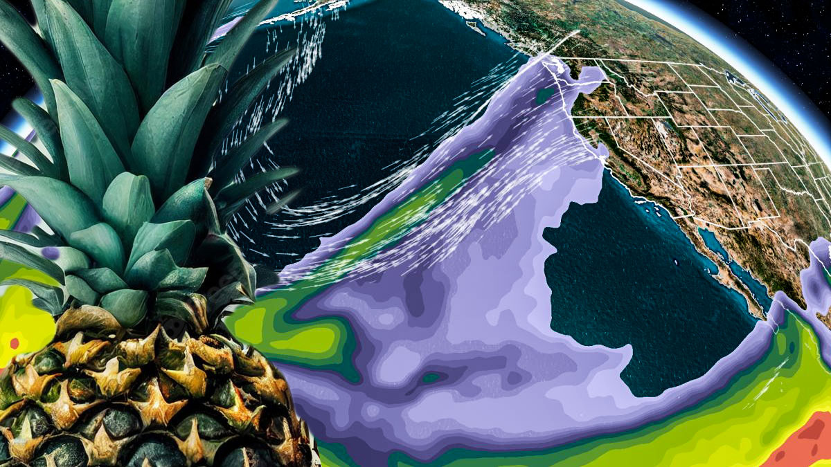
Atmospheric river storms, also known as “pineapple express” storms, have sometimes been known to bring much-needed rain and snow to drought-stricken areas, including California.

Extreme weather, wildfires, and more have been on the increase worldwide as a result of global warming and climate change.

Atmospheric river storms are characterized by a narrow corridor of strong winds and heavy precipitation that can extend for thousands of miles. They are often associated with the transport of moist air from tropical regions, and they can be a significant source of water for many areas.

In California, atmospheric river storms can provide a much-needed source of water for agriculture, hydroelectric power generation, and other important water-dependent activities.

They can also help to replenish reservoirs and groundwater aquifers, which can help to mitigate the impacts of drought.

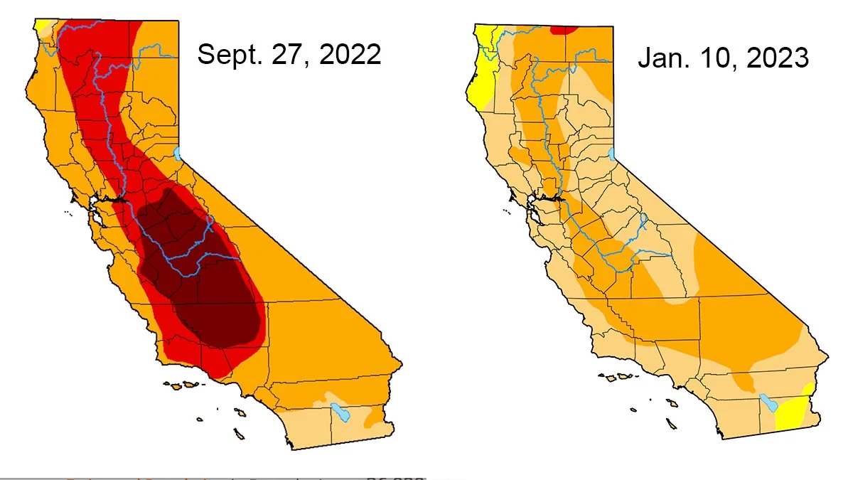
The monumental drought of 2022 in the rearview?

Just as it was looking as if there was zero chance for enough moisture to reverse the long, intense drought conditions that California has suffered this year, the “Pineapple Express” became a holiday storm front. There is a sense of relief, although it is too early to tell if the drought will end as a result of this rain.

It is also important to note that these storms can also bring heavy rainfall and strong winds, which can lead to flooding and other hazards. As a result, it is important for people in affected areas to be prepared and take necessary precautions.

An atmospheric river is a narrow band of moisture-rich air that extends from the tropics or subtropics to higher latitudes. These rivers of air are typically about a thousand miles wide and several thousand miles long, and they can transport enormous amounts of water vapor from the tropics to other parts of the world.

Atmospheric rivers are important because they play a crucial role in the global water cycle.

Water evaporates from the surface of the ocean, rises into the atmosphere, and then condenses to form clouds. As the clouds move over land, they release their moisture in the form of rain or snow.

Atmospheric rivers are responsible for a large portion of the moisture that falls as precipitation in many parts of the world, particularly along the western coasts of the United States, Europe, and Asia.

Atmospheric rivers can be either warm or cold, depending on the temperature of the air that they are carrying.

Warm atmospheric rivers are typically associated with heavy rainfall and floods, while cold atmospheric rivers can bring snow and ice to colder regions.

One of the most well-known atmospheric rivers is the “Pineapple Express,” which is a warm atmospheric river that brings moist air from the tropics to the Pacific Northwest of the United States.

The Pineapple Express is named after the tropical fruit because it brings warm, tropical air to the region. This atmospheric river is responsible for a large portion of the precipitation that falls in the Pacific Northwest, and it can cause heavy rainfall and floods in the region.

Another well-known atmospheric river is the “North Atlantic Oscillation,” which is a cold atmospheric river that brings moist air from the subtropics to the northeastern United States and eastern Canada.

This atmospheric river is responsible for a large portion of the snowfall that falls in these regions, and it can cause heavy snow and ice storms.

Atmospheric rivers can have a significant impact on the weather and climate of the regions that they affect.

They can bring much-needed moisture to dry regions, which can help to alleviate drought conditions. However, they can also cause heavy rainfall and floods, which can lead to damage to infrastructure and loss of life.

In recent years, there has been an increasing awareness of the importance of atmospheric rivers and their potential impact on the global water cycle.

Scientists are working to better understand atmospheric rivers and to develop better tools for predicting and managing their effects.

This research is important because atmospheric rivers are likely to become more intense and more frequent in the future due to climate change.

Generally speaking, an atmospheric river is a narrow band of moisture-rich air that extends from the tropics or subtropics to higher latitudes.

These rivers of air play a crucial role in the global water cycle and can bring much-needed moisture to dry regions or cause heavy rainfall and floods.

There is an increasing awareness of the importance of atmospheric rivers and their potential impact on the global water cycle, and scientists are working to better understand and predict their effects.

Please help keep us publishing the content you love

Lynxotic may receive a small commission based on any purchases made by following links from this page