Tag Archives: blizzard

Why a warming climate can bring bigger snowstorms

Above: Photo by Josh Hild from Pexels

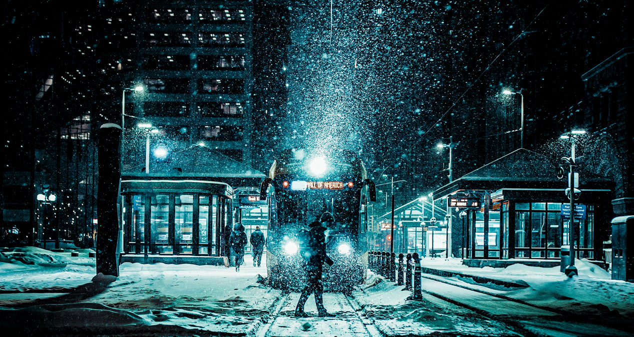
The blizzard that buried Boston under nearly 2 feet of snow in January 2022 was historic, but not a surprise. Over a century of reliable weather records show many of the Northeast’s heaviest snowfalls have occurred since 1990 – including seven of the top 10 in both Boston and New York.

At the same time, winters in the Mid-Atlantic and Northeast have warmed by approximately 4 degrees Fahrenheit (2.2 C) since the late 1800s.

How can the spate of big snowstorms be reconciled with our warming climate? I’m an atmospheric scientist. Let’s look at an important law of physics and some theories that can help explain the changes.

Warmer air, more moisture

First, warmer air can hold more moisture than cold air.

Think of the atmosphere like a sponge. Air holds about 4% more water vapor for each additional degree Fahrenheit increase in temperature (that’s about 7% per degree Celsius). The physical law that explains this relationship is known as the Clausius-Clapyron relation.

This increased atmospheric moisture is helping to intensify the water cycle. The Northeast and Mid-Atlantic have become wetter – not just in winter, but in spring, summer and fall, too. In addition to more total precipitation over a season and year, the additional moisture also fuels extreme events, like more intense hurricanes and flooding rains. The Northeast has seen an increase of more than 50% in the heaviest precipitation events in recent decades, the largest increase of any region of the U.S.

In the early 1900s, winters across the Northeast typically averaged around 22 degrees Fahrenheit. Now, 26 degrees is the official new “normal” temperature, defined as the average over 1991-2020. A few recent winters have been over 30.

In the Northeast, then, we have an environment that has warmed yet is often still below freezing. Put another way, regions of the world that are cold enough for snow have warmed enough to now be visited by storms capable of holding and dropping more moisture. Rather than intense downpours like Louisiana has been seeing lately, the region gets heavy snow.

The warming ocean plays a role

The January blizzard was fueled by ocean waters in the western Atlantic that are warmer than normal. That’s also part of a consistent pattern.

The oceans have been absorbing more than 90% of the additional heat attributable to rising atmospheric greenhouse gases from human activities, particularly burning fossil fuels. The oceans now contain more heat energy than any time since measurements began six decades ago.

Scientists are studying whether global warming may be driving a slowing of the ocean conveyor belt of currents that transport water around the globe. Satellite imagery and ocean measurements show that warmer waters have “piled up” along the East Coast, a possible indication of a slowing of the Atlantic Meridional Overturning Circulation.

Moisture evaporated from ocean water provides much of the energy for both tropical and mid-latitude extra-tropical cyclones, known commonly as nor’easters.

The Arctic influences the snow pattern, too

While tropical storm systems are fueled primarily by warm water, nor’easters gain energy from sharp temperature gradients where cold and warm air masses meet. The frequency of cold air outbreaks is another aspect of climate change that may be contributing to recent increases in extreme snowfall events.

Recent research has suggested that a warming Arctic, including declines in Arctic sea ice and snow cover, is influencing behavior of the polar vortex, a band of strong westerly winds that forms in the stratosphere between about 10 and 30 miles above the Arctic every winter. The winds enclose a large pool of extremely cold air.

When the Arctic is relatively warm, the polar vortex tends to be weaker and more easily elongates or “stretches,” allowing extremely cold air to dip south. Episodes of polar-vortex stretching have markedly increased in the past few decades, leading, at times, to more severe winter weather in some places.

Scientists Are Very Worried About Antarctica’s Doomsday Glacier:

Check out Lynxotic on YouTube

What is the polar vortex? NASA explains.

Arctic amplification, the enhanced warming to our north, may, paradoxically, be helping to shuttle cold air to the Eastern Seaboard during polar vortex disruptions, where the cold air can interact with warmer, moisture-laden air from the warmer-than-normal western Atlantic Ocean. The most recent stretched polar vortex event helped to bring together key ingredients for the historic blizzard.

What’s ahead?

Global climate models project an increase in the most extreme snowfall events across large areas of the Northern Hemisphere with future warming. In some other parts of the world, like Western Europe, intensification of the hydrological cycle will mean more winter rain than snow as temperatures rise.

For the east coast of North America, as well as Northern Asia, winter temperatures are expected to still be cold enough for storms to bring heavy snow – at least through mid-century. Climate models suggest that extreme snowfalls will become rarer, but not necessarily less intense, in the second half of the century, as more storms produce rain.

The sharp increase in high-impact Northeast winter storms is an expected manifestation of a warming climate. It’s another risk the U.S. will have to prepare for as extreme events become more common with climate change.

Michael A. Rawlins, Associate Director, Climate System Research Center, UMass Amherst

This article is republished from The Conversation by Michael A. Rawlins, UMass Amherst under a Creative Commons license. Read the original article.


Find books on Climate Science and Sustainable Energy Solutions and many other topics at our sister site: Cherrybooks on Bookshop.org

Lynxotic may receive a small commission based on any purchases made by following links from this page

These Extreme Weather Events are a preview of the Coming Climate Disasters

Above: Photo Collage – Lyxotic

New Orleans, Lake Tahoe, NYC – that’s just this week and just in the US… and a drought in the west that is a serious growing threat

The warnings are coming hard and heavy after multiple previous and eerily similar catastrophes, only they just keep getting more severe. Each one is a unique event and each has a litany and list of records that smash all prior statistics since record keeping began.

“Hottest month ever”, “most rainfall in an hour ever recorded”, “worst flood in NY history”, these hyperbolic sounding statements are not hyperbole at all, just facts, but since they are becoming a nearly constant refrain, the entire situation appears surreal.

Journalists use words like “dystopian” and twitter users compare photos and general panic to the climate disaster movie “The Day After Tomorrow” and note that the current reality is already scarier than what the movie was able to convey.

Underneath the shock is a layer of manufactured apathy

Even as the signs of an expanding and accelerating worldwide disaster are more obvious, season by season, month by month and even day by day, there is, nevertheless, a kind of paralysis surrounding the fear.

Fossil fuel subsidies continue to be handed out, so many half-measures and excuses are bandied about, and personal, individual responsibility is used as a bludgeon to guilt the populous into a state of inaction.

It’s called a climate emergency because it is an emergency, so act like it, to paraphrase Greta Thunberg. Unfortunately, dire emergencies are not scarce at the moment, and the situation is likely to get worse, meanwhile it is a valid question; what would be done if the climate crisis were actually treated like an emergency?

New York Floods, Ida aftermath, September 2021

Above: Photo: Lyxotic / Adobe Stock

The remnants of Hurricane Ida resulted in extreme dumping of historic levels of rainfall, with Central Park in N.Y.C. receiving 3.15 inches of rain in just one hour. Newark Airport was shut down and many flooded streets in the five boroughs and surrounding areas of New Jersey and Pennsylvania were transformed into virtual rivers. Subway entrances and basement dwellings quickly filled until they overflowed.  

The national Weather Service issued its first ever “flash flood emergency” for the area as well as both NY and NJ leaders issuing states of emergency.

The death toll quickly rose to at least 50 people. Reports of those that were killed mostly died as a result of being flooded in basement living spaces or overtaken by water both inside and outside their vehicles. 

The Climate Crisis is not a movie and a majority has to demand action of Government and Industry: the individual is not to blame

In a way the problem inherently contains the seeds to its own resolution. The current state of climate emergency could have been partially averted, or at least slowed down, had government and, in particular, the fossil fuel industrial complex done more than talk and come up with tricks like greenwashing and propaganda to distract and delay the obvious need to stop carbon (CO2) pollution. The signs were evident for many decades, and some alternative solutions were known for over a century, while the fossil fuel behemoth just kept expanding.

Now, with the crisis getting more extreme and deadly, seemingly by the hour, it will take an equally extreme change in the response – a literal washing away of the status quo that created the problem. That may look like a system wide collapse, bringing down the structure that props up the suicidal stupidity of the current system, or something equally extreme, if real solutions are to have time to have any chance of having an impact.

New Orleans Storm

Hurricane Ida made landfall as a Category 4 Sunday morning (August 30, 2021) also marking the 16th anniversary of Hurricane Katrina.  Ida had maximum sustained winds of 150 mph,  just shy of making it a Category 5 (winds greater than 155 mph). Radar approximates that up to about 17 inches of rainfall were recorded just west of New Orleans. 

Over a million customers lost power in Louisiana, making it the 2nd largest power outage in the state since 2000. The outage could leave residents without power for up to six weeks, rendering them helpless for electricity during increasingly hot late summer weather. Numerous streets need power lines raised that were brought down or snapped by Ida’s winds. 

Cantrell, the New Orleans major spoke of voluntary evacuations, particularly for residents that have special needs, seniors or those vulnerable to the heat. 

Extreme weather, ocean temps, rising sea levels with melting ice caps, all connected and all increasingly menacing

It has appeared, unfortunately, for nearly decades as if the predictions of ocean temperature increase and sea level rise would have to continue until multiple major cities are fully submerged before any real steps would begin to combat the causes.

Is that still the case after the four “disaster stories” this week? Was the tragedy and destruction enough to have people begin to actually realize that there are no decades left to “wait and see”?

Caldor / Lake Tahoe Fire

The Caldor Fire has burned around 213,270 acres covering 2 California counties (El Dorado and Amador) and currently only 32% contained (as of September 3rd).  The fires have been active for 19 days according to Cal Fire.   Thousands of  people have been forced to evacuate.  The looming threat of the fires reaching the popular tourist location of South Lake Tahoe are safe for now, however, and flames have been averted. 

The fire created widespread haze and smoke, resulting in extremely hazardous air quality. 

The total number of structures destroyed by the fire is 857 as of Sept 3rd, marking it as the 20th most destructive fire in recorded history for California. 

Monumental Drought in the Western US

All of California is under a drought conditions. 

Water levels from the largest reservoir on the Colorado River and Lake Mead,  which supply drinking and irrigation water to Colorado, Nevada, Arizona, California and Mexico  have reached record low levels.

Regulators now have to make crucial steps to protect another crucial water source, the Sacramento-San Joaquin Delta, the water system that helps to provide 2/3 of CA population, irrigation for agricultural industry as well as state’s norther border with Oregon. 

California residents could be facing future water restriction, however according to Gov. Gavin Newsom it is not likely to be in force until the end of September (the delay could be his attempt to avoid any unpopular mandates before the  Sept 14. Recall Election).

Some drastic measures have been taken so far at National State parks in order to help conserve water including closing bathrooms and showers and shutting off water faucets/fountains.

Four stories just from this week: is this a turning point and a wake up call that we desperately need?

Does New York City, or Miami, or Mumbai have to be permanently flooded or fully submerged before we “notice” and demand action? Or, is now the time to mark the date – September 2021 as the moment that the climate emergency was finally “real”? Will it be seen, understood as imminent, and acted on as an emergency of the magnitude that it already is?


Find books on Sustainable Energy Solutions and Climate Science and many other topics at our sister site: Cherrybooks on Bookshop.org

Enjoy Lynxotic at Apple News on your iPhone, iPad or Mac.

Lynxotic may receive a small commission based on any purchases made by following links from this page